Stock
Photo
Video
Audio
Vector
Collections
Packages
Lightboxes
Prints and Products
Wall Art
Canvas Prints
Framed Prints
Prints and Posters
Metal Prints
Acrylic Prints
Phone Cases
iPhone Cases
Galaxy Cases
Home Decor
Pillows
Duvet Covers
Shower Curtain
Clothes
T-Shirts
Souvenirs
Greeting Cards
Bags
Tote Bags
Categories
Site info
About
Support
Privacy Policy
FAQ
Contact Us
Google map
Shopping Cart
Member Area
English
Your Shopping Cart is empty.
Total:
View cart
Checkout
Search
Keywords:
Creator ID:
Type:
Photo
Illustration
Vector
Video
Template
3d
Categories:
Animals
Buildings and Architecture
Business
Drinks
The Environment
States of Mind
Food
Graphic Resources
Hobbies and Leisure
Industry
Landscapes
Lifestyle
People
Plants and Flowers
Culture and Religion
Science
Social Issues
Sports
Technology
Transport
Travel
News
Entertainment
Sport News
Languages:
Brazilan Portuguese - Brazil
English - Canada
French - Canada
Spanish - Mexico
English - United States
English - Belgium
French - Belgium
Dutch - Belgium
Czech - Czech Republic
English - Cyprus
Danish - Danmark
German - Germany
English - Estonia
Spanish - Spain
French - France
French - Marocco
English - Greece
English - Ireland
Italian - Italia
English - Latvia
English - Lithuania
German - Luxembourg
English - Luxembourg
French - Luxembourg
English - Hungary
English - Malta
Dutch - Nederlands
Bokmal Norwegian - Norway
German - Austria
Polish - Poland
Portuguese - Portugal
English - Romania
German - Switzerland
English - Slovenia
Slovakian - Slovakia
French - Switzerland
English - Finland
Swedish- Sweden
Italian - Switzerland
English - United Kingdom
English - Bulgaria
English - Australia
Japanese - Japan
Korean - South Korea
English - New Zealand
Russian - Russia
English - Ukrain
English - Thailand
Orientation:
All
Horizontal
Vertical
square
Color:
Model property release:
All
Yes
No
Duration Video:
All
Up to 10 seconds
Up to 20 seconds
Longer than 30 seconds
Results
(0)
Site
Getty/iStock
Shutterstock
Fotolia
Depositphotos
123rf
Bigstockphoto
Pixabay
Adobe Stock
Relevance
New
Most popular
Most downloaded
Undiscovered
12
24
36
48
96
Auto paging
Menu
Uffington White Horse, prehistoric hill figure, 110 m long, formed from deep trenches filled with crushed white chalk, created some time between 1380 and 550 BC, during Bronze Age or early Iron Age.
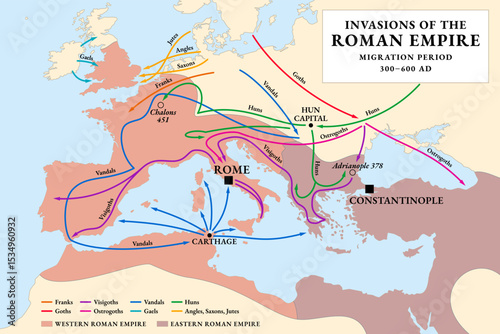
Invasions of the Roman Empire, historical map. Migration Period, or also the Barbarian Invasions, from 300 to 600 AD. A period in European history marked by large-scale migrations by various tribes.
Sahara, Sahel, and Sub-Saharan Africa, colored political map. Sahara, largest hot desert in the world, and most of North Africa. South of it the Sahelian acacia savanna, part of Sub-Saharan Africa.
Europe, Middle East, and North Africa, gray political map with international borders. Overview of continent Europe, geopolitical region Middle East, and the northern portion of the African continent.
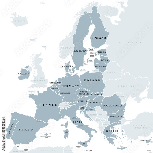
European Union, member states of the EU, gray political map. Economic and political union of 27 member states. Map with single countries, labeled in english, and with international borders. Vector
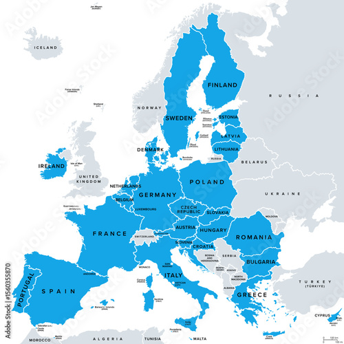
European Union, member states of the EU, political map. Economic and political union of 27 member states, colored in blue. Map with single countries with international borders, labeled in English.
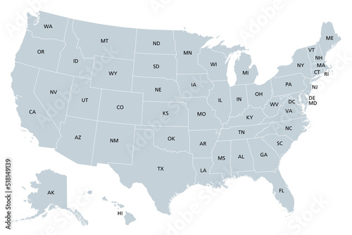
United States of America, gray political map. Fifty single states with their own geographic territories and borders, bound together in a union and federal government. Labeled with USPS abbreviations.
Europe, Middle East, and North Africa, political map with international borders. Overview of the continent Europe, the geopolitical region Middle East, and northern portion of the African continent.
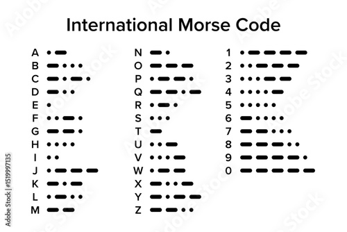
International Morse code, chart with 26 letters and 10 numerals. Telecommunications method which encodes text characters as standardized sequences of two different signal durations, dots and dashes.
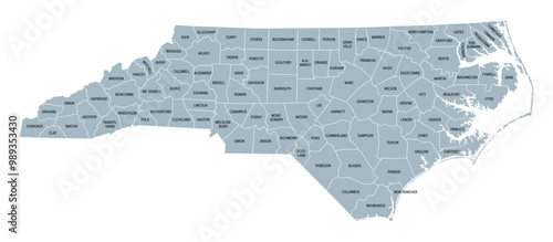
North Carolina counties, gray political map with borders and county names. State in the Southeastern region of United States subdivided into 100 counties. Nicknamed Tar Heel State and Old North State.
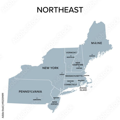
Northeast, census region of the United States of America, gray political map of census region 1, consisting of 9 single states. Map with geographical borders and capitals. Isolated illustration.
Rabbit-duck illusion. An Ambiguous image, reversible figure, and optical illusion in which a rabbit or a duck can be seen. After an unattributed drawing and earliest known version from 1892. Vector.